Final Leg, Arrival, and First Few Days

It’s been some time since the last post, due to not having internet at our new home yet, so this will be a bit long winded.

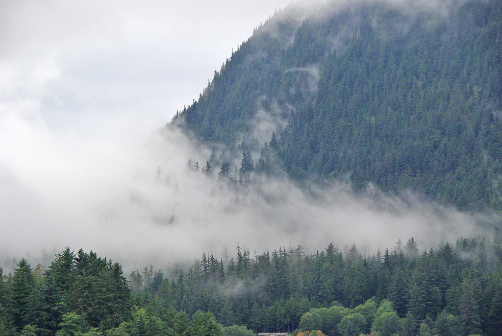
The final leg of our ferry trip was quite the adventure. From Juneau to Yakutat was fairly uneventful, mostly an over night trip. Leaving Juneau the fog around the hills was really a pretty sight. We saw a couple glaciers leaving also, took some photos, but they are from quite a distance. The real issues/problems started after leaving Yakutat heading to Whittier across the Gulf of Alaska. The seas started to roll, and I mean roll, 12 to 18 FT seas were really making the ferry rock, bob and roll. We did fine the first evening, was just a bit hard to walk around the ship. The next day and night were the tough ones. Jan and Maddie both got sea sick with Maddie blowing some chunks, both spending the day and night in bed. I did OK. I kept my eyes on the horizon so not to see/feel the rolling so much and also I kept eating so that my belly was full. While walking around the ferry during the day the weather was rainy, but I kept going out on deck for some fresh air. (Although, I did feel kind of crappy the day after we got to the house.) One time out on deck,I saw a water spout, the photo is below but its not that great due to the rolling of the ship. 

Arriving in Whittierwas quite something also. It was about 7:00 AM and the wind was still blowing a gale, the ship even had to take a 2nd attempt at docking. The wind, rain and fog were coming down so hard you couldn’t see squat. They called it gale force fog. The rain and fog were both moving sideways, not just on an angle, but sideways and sometimes even up. There was a waterfall we passed just out of Whittier that, due to the wind, in spot it was going up, not down, was quite the sight. After we got a few miles out of Whittierthe skies started to clear. The trees were/are in full color as you’ll see from some of the photos.

We called our new landlord from Girdwood to say we have arrived. He told us to call him back once we got to Wasilla and he would either meet us at our home or anywhere else. After the wonderful drive to Anchorage then up to Wasilla, we called him back and he lead us to our new home. What a great feeling it was to finally be here. The house is better than what we thought from the photos, which is really great. There are some quarks, but what house doesn’t have em. We have a view of the Talkeetna Mountains out our north windows. Speaking of mountains, when we arrived all but the tallest peaks were green (no snow), but just in the few days we’ve been here just about all the mountains have snow above 2000 FT.

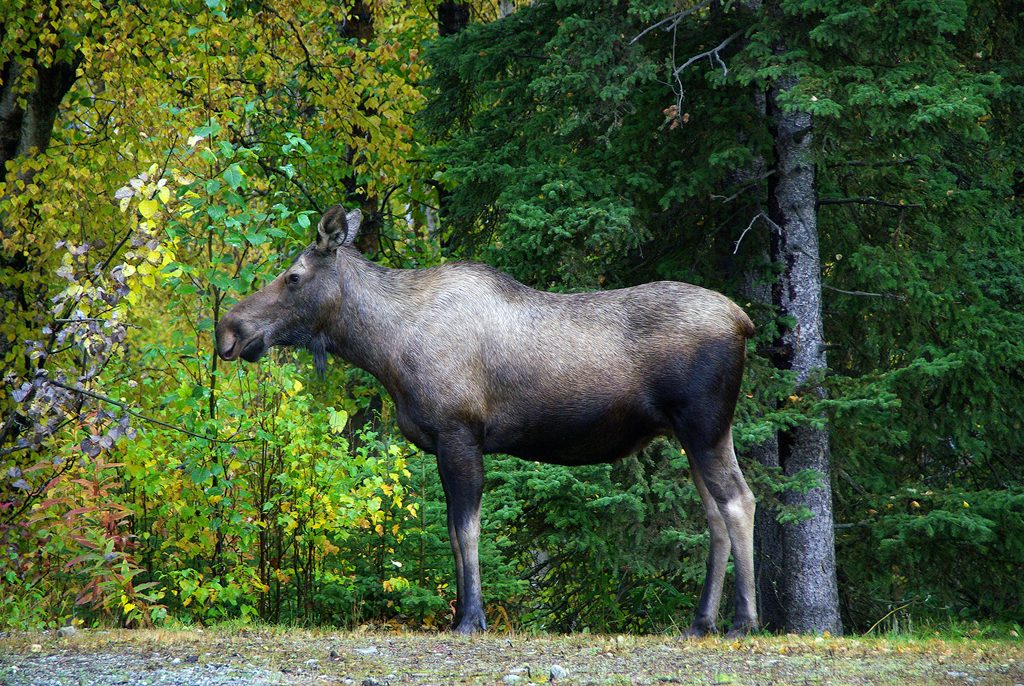
On our third day in the house, after the dogs had been out, I went outside, glanced to my right, took a second look and there they were…Moose laying in our yard. A mom and her 2 yearlings just laying there munching on the grass.Shortly after we let the dogs out in their pen to see what they would do. They really didnt do much at all but stare at the moose wondering what the hell they were. No matter what, it was great to have the moose stop byto say hello and welcome to Alaska.

The weather here has been kind of up and down, some rain, some sun, with the temps in the upper 40s to mid 50s. Mostly rain today though. We havent had time to go sight seeing due to trying to get settled in and learn the area for shopping and such. We do plan on gong up to Hatcher Pass this coming weekend, they are calling for good weather, mostly sunny with temps in the 50s, before the snow gets too deep up there.

On to the photos…

Leaving Juneau

Juneau Ice Field

Mendenhall Glacier just outside of Juneau

Lighthouse heading out from Juneau

The Waterspout

Kayak Island, the first bit of land we saw in a damn long time

Purser Area on our ferry

Hallway on ferry

The sick bags were placed all over the ferry

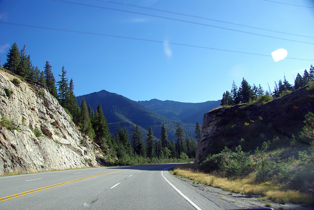
Seward Hwy just after leaving the ferry in Whittier

At our home and starting to unpack

View from the house the day we arrived

And today, notice the snow

The moose that stopped by

Our view while driving in and out of Wasilla

I think that’s about it for now, need to get out and get some dog food and new tags.

’till next time
Laters
Ed

Juneau

We’ve made it to Juneau, AK. Rainy Juneau that is. The ferry trip has been great, lots of very friendly people from all over the US and other countries. We ended up with a great cabin on the starboard (right side) bow with 2 big windows, great views. I have lots of pictures to post and these are just a handfull of what I took.

The following photos are from the first day leaving Bellingham.

First Day on Ferry:

Sitting in line to board the ferry.

Jan made it on sooner than I did. She’s looking out in my direction.

Moon over Bellingham.

Mt. Baker.

Sunsets from the ferry.

Day 2 on Ferry:

Humpback Whales

Random Inside Passage Pics

Narrow Passage.

Moving Home The Alaska Way.

Ocean Tribe Homestead.

Inside Passage Navigation Lights.

Tlingit Village Lodge.

Day 3 on Ferry:

More of The Inside Passage just south of Ketchikan.

Arriving into Ketchikan.


Yes that’s snow, but it was in the mid 50’s

4 Alaska Ferry’s at dock.

No Roads in or out, everything comes this way.

Day 4 on Ferry and Juneau:

Bald Eagles

River in Cope Park Juneau

Fog in Juneau

Waterfall, Juneau

Ahh, Yes, Alaska has Vernors! Life is good! And, it’s in a glass bottle.

That’s it for now. Next post will be from our new home in Wasilla.

Laters from Juneau
Ed

Boarding The Ferry

Boarding the ferry today.

Here is our vessel and info about it:

M/V Malaspina

The M/V Malaspina carries 499 passengers, and provides 46 four-berth and 26 two-berth cabins, one of which is wheelchair accessible. The vessel was built in Seattle in 1963 at the Lockheed Shipbuilding yards, then lengthened and renovated in 1972 at the Willamette Iron and Steel Company shipyard in Portland. The Malaspina is now 408 feet long, with capacity for 88 vehicles (20′ lengths), and a service speed of 16.5 knots. Passenger services include a cafeteria, gift shop, cocktail lounge, solarium, and forward observation lounge.

That’s about it for today. I’ll post when I get the chance in a few days.

Laters
Ed

Photos From Yesterday

On with the story from yesterdays travel.
We made it down from that 6 mile, 9% grade Waterville hill and arrived in Leavenworth. We stopped in a KOA to talk with someone about the next leg of our travel, through Stevens Pass. Well, the lady we spoke to was really surprised we went down Waterville hill, saying they hate that section and never drive it. She, and her husband, reasured us that Stevens Pass was nothing like the hill from Waterville, only a 4-5% grade down. With that, we pressed on. They were right, the pass was much easier than Waterville. Thank you KOA.

We arrived at Burlington KOA just after dark to sleep the day’s trip off.

Friday the 18th we board the ferry to Whittier Alaska.

These are the photos I took yesterday. We weren’t able to stop anywhere, so all these are while driving.

Dust Devils. We ended up driving through one, that was a bit a strange feeling, made the Jeep wiggle around some.

Click this image and see how many Dust Devils you can count.

A Meteor? Probably Not.

The Following 6 Are Passing Through Armour Draw.

Just A Couple Of Barns.

Douglas Washington

The Next 10 Shots Are of The Scarry Bit We Drove Down At 9% Grade From Waterville. It doesn’t Look Like Much, But It Sure Was!

This Is Coming Through Stevens Pass Down The Mountains Toward Seattle.

And Just For Fun, An Old Ford Falcon

I thnk that’s it for now. I’m not sure when I’ll be posting again due to no internet conection on the ferry. At the very latest, I’ll be posting from our new home in Wasilla, AK sometime the week of the 22nd of September.

Until then, happy trails and keep the shinny side up.

Laters,
Ed

Made It To Seattle

We made it! To Seattle at least. And what a trip this last day has been. We left Spokane about 10:30 AM and headed west on US-2. All was well ’til we came to Waterville, with an altitude of 2650 FT, not really all that high compaired to where we have been this trip. Anyway, driving along we see a sign that states “Truck Brake Lane Ahead” we should have known by that sign of what was to come, but no, we pressed forward. The hill down, as we found out later, was a 9% grade for about 6 miles and around u-corners through a gorge. The truck’s brakes where smoking even while in 2nd gear. We did make it, obviously.

Ok, too damn tired to type any more tonight, so stopping for now and will post pictures and more details of the trip tomorrow.

Laters
Ed

Montana, Idaho, Washington

Today we drove from the western bit of Montana, through North Idaho, into Spokane Washington. Didn’t have time to take any pics today, only a couple as we passed into Idaho. Don’t know how, but I missed the Washington border, oh well. Only one more day of driving until we board the Alaska Marine Highway (ferry). The bit of Montana we drove today was really wonderful, just really nowhere to stop and shoot photos. It’s so nice to see lakes that aren’t lined with homes, just one here and there, but not circling the water.

Eric, I did see some, quite a few really, old “corn binders” (International Harvester) in great condition. But with the speed limit at 70mph on roads like US31, they reduce the speed to 60 in tricky bits, it’s tough to snap photos while driving. I know Norm, 10 more demerits.

So anyway, just think of yourself driving along and taking the pictures. They are only of the passing a state line but what the heck.

’til next time,
Laters,
Ed

Lost In Montana

Today we decided to have short easy day to help rest up a bit, so we headed just around the corner to Hungry Horse Dam. After checking out the dam, we choose to continue on down the same road that runs along the edge of Hungry Horse Reservoir. Little did we know how large the reservoir is. Was a nice paved drive for quite some time, then the pavement ended, the road narrowed, went higher, and the edges got steeper. I had my GPS, but I didn’t have all the area maps needed. We just kept driving. And driving. After about 4 hours we made our way around the reservoir and ended up about 1 mile from where we started.

Hungry Horse Dam.

Tomorrow we head off to Spokane WA. to continue our journey.
Laters
Ed

Going-to-the-Sun Road

OK, we had a great ride today traveling the "Going-to-the-Sun Road". All I can really say is if you ever have the chance to drive this, DO IT.

The following is from Wikipedia:
"Going-to-the-Sun Road is the main parkway through the heart of Glacier National Park in Montana, USA. It was completed in 1932, and it is the only road that crosses the park, going over the Continental Divide at Logan Pass. A fleet of 1930s red tour buses "jammers", rebuilt in 2001 to run on propane or gas, offer tours on the road. The road, a National Historic Landmark and a Historic Civil Engineering Landmark, spans 53 miles (85 km) across the width of the park.

The road is one of the most difficult roads in North America to snowplow in the spring. Up to 80 feet (25 m) of snow can lie on top of Logan Pass, and more just east of the pass where the deepest snowfield has long been referred to as Big Drift. The road takes about ten weeks to plow, even with equipment that can move 4000 tons of snow in an hour. The snowplow crew can clear as little as 500 feet (150 m) of the road per day. On the east side of the continental divide, there are few guardrails due to heavy snows and the resultant late winter avalanches that have repeatedly destroyed every protective barrier ever constructed. The road is generally open from early June to mid October.

The two lane Going-to-the-Sun Road is quite narrow and winding, especially west of Logan Pass. Consequently, vehicle lengths over the highest portions of the roadway are limited to 21 feet and that means no recreational vehicles or trailers in excess of this length restriction are permitted beyond two larger parking areas, each located at lower points dozens of miles below Logan Pass, on both the west and east sides of the parkway."

Anyway, lots ‘n lots of pics to show, so here we go…
Again, just a reminder, Click the Pic to get the larger Image.

One of the pull-offs along the road.

The "ring" around the mountain you see is the road.

There is no going around this spot, must go through.

I think Eli might be a bit dizzy from the drive

Jan and Maddie

Columbian Ground Squirrel

Looking down a few hundred feet.

And last but not least, we say this bear on the hill side along the road.

Yikes, that’s it for now.
Laters
Ed